


ROMINE Voting District, Marion County, Illinois
About
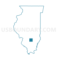
Outline

Summary
| Unique Area Identifier | 573494 |
| Name | ROMINE Voting District |
| County | Marion County |
| State | Illinois |
| Area (square miles) | 35.96 |
| Land Area (square miles) | 35.90 |
| Water Area (square miles) | 0.05 |
| % of Land Area | 99.85 |
| % of Water Area | 0.15 |
| Latitude of the Internal Point | 38.51690190 |
| Longtitude of the Internal Point | -88.75895600 |
Maps


Graphs
Select a template below for downloading or customizing gragh for ROMINE Voting District, Marion County, Illinois


Neighbors
Neighoring Voting District (by Name) Neighboring Voting District on the Map
- FARRINGTON Voting District, Jefferson County, IL
- HAINES Voting District, Marion County, IL
- HICKORY HILL TWP Voting District, Wayne County, IL
- IUKA Voting District, Marion County, IL
- ORCHARD TWP Voting District, Wayne County, IL
- STEVENSON Voting District, Marion County, IL
Top 10 Neighboring County Subdivision (by Population) Neighboring County Subdivision on the Map
- Stevenson township, Marion County, IL (1,301)
- Haines township, Marion County, IL (1,002)
- Iuka township, Marion County, IL (999)
- Orchard township, Wayne County, IL (604)
- Farrington township, Jefferson County, IL (567)
- Romine township, Marion County, IL (514)
- Hickory Hill township, Wayne County, IL (413)
Top 10 Neighboring Elementary School District (by Population) Neighboring Elementary School District on the Map
- Iuka Community Consolidated School District 7, IL (1,966)
- Kell Consolidated School District 2, IL (1,023)
- Farrington Community Consolidated School District 99, IL (610)
Top 10 Neighboring Secondary School District (by Population) Neighboring Secondary School District on the Map
- Salem Community High School District 600, IL (15,204)
- Webber Township High School District 204, IL (2,958)
Top 10 Neighboring Unified School District (by Population) Neighboring Unified School District on the Map
Top 10 Neighboring State Legislative District Lower Chamber (by Population) Neighboring State Legislative District Lower Chamber on the Map
Top 10 Neighboring State Legislative District Upper Chamber (by Population) Neighboring State Legislative District Upper Chamber on the Map
Top 10 Neighboring 111th Congressional District (by Population) Neighboring 111th Congressional District on the Map
Top 10 Neighboring Census Tract (by Population) Neighboring Census Tract on the Map
- Census Tract 9550, Wayne County, IL (4,360)
- Census Tract 9522, Marion County, IL (4,181)
- Census Tract 502, Jefferson County, IL (3,120)